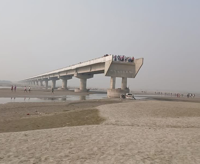
A deadly car crash in India raises concerns about Google Maps

Can Navigation Apps Be Held Accountable for Accidents?
This is the question currently being debated in India after a tragic incident in which three men died when their car drove off an unfinished bridge and plunged into a riverbed in Uttar Pradesh. Police are investigating the crash, which occurred on Sunday, and suspect that Google Maps led the men to the route.
Reports suggest that part of the bridge had collapsed earlier this year due to floods, and while locals knew of the danger and avoided the area, the three men were unfamiliar with the location. There were no barriers or warning signs indicating that the bridge was incomplete. As a result, authorities have filed a police complaint naming four engineers from the state’s road department and an unnamed Google Maps official, accusing them of culpable homicide.
A Google spokesperson has stated that the company is cooperating with the investigation.
This accident has brought attention to India’s inadequate road infrastructure and sparked a debate about whether navigation apps like Google Maps should be held responsible for such incidents. Some people blame the app for providing incorrect or outdated information, while others argue that the government is at fault for failing to secure the site.
Google Maps, which is the most popular navigation app in India, is synonymous with GPS and is used by millions for ride-sharing, e-commerce, and food delivery services. The app has around 60 million active users in India and handles approximately 50 million searches daily. However, it has faced criticism in the past for giving misleading directions, sometimes leading to fatal accidents.
In 2021, a man in Maharashtra drowned after driving his car into a dam while allegedly following directions from Google Maps. In another incident last year, two young doctors in Kerala died after their car veered off a flooded road, following a route suggested by the app. The police warned people not to rely solely on Google Maps during floods.
So, how does Google Maps stay updated about changes in road conditions? The app uses GPS signals from users to track traffic patterns—an increase in signals indicates congestion, while fewer signals suggest that a road is less traveled. Google also receives traffic information from users and local governments about road closures or jams.
According to Ashish Nair, founder of Potter Maps and a former Google Maps employee, complaints about traffic or road closures are prioritized, but given the sheer volume of complaints, Google cannot address them all. A map operator then uses satellite imagery, Google Street View, and government updates to verify changes and update the map accordingly.
Nair argues that GPS apps cannot be held responsible for accidents because their terms of service state that users should use their own judgment while navigating, and the app’s data may not always reflect current conditions. Moreover, it’s incredibly challenging for Google, which manages maps globally, to keep track of every change in real-time, especially in a country like India, where rapid development makes it difficult to gather accurate data.
India also lacks a system for quickly reporting changes in infrastructure that can be shared with apps like Google Maps. Nair points out that countries like Singapore have systems for logging such changes, but India’s vast size and fast-paced development present unique challenges for accurate mapping.
The issue of whether GPS apps can be held legally responsible for accidents is still debated. Advocate Saima Khan explains that, under India’s Information Technology (IT) Act, platforms like Google Maps are considered “intermediaries” and are not liable for the content they distribute. However, she notes that if it can be shown that the app failed to update its data despite being given correct information, it could be held responsible for negligence.
